Brian Ramler is playing the guessing game these days.
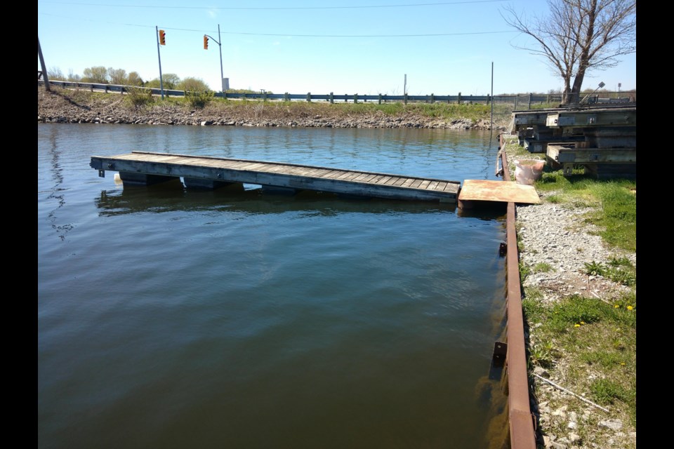
The owner of Twin Bridge Marina in Waubaushene said he has been waiting for the lake to settle down so he can figure out the best height to put in the docks.
"I've already bought two truckloads of fill and I'm going to have to buy more," said Ramler. "I just did this temporarily until I get myself going here because everything is delayed, partly because of COVID and partly because of lake levels being so high a month ago.
"I've been on hold now for a month to get any outside work done. I can't bring in a truck when the lake is over top of my steel wall."
The cost for the fill, he said, could go up to $10,000, and that might not even solve the problem.
"It's (also) going to impede my gas sales," said Ramler. "If the water comes up any higher than it is now it's going to be a struggle for the clientele to be able to tie up their boat on my gas dock and be able to get out of their boat to refill it."
The long-time marina operator said it's getting harder and harder to deal with the docking as water levels keep rising.
"We never know what height to put the docks at because we never know where the water is going to be," said Ramler. "And nobody can really tell us."
This year, Lake Huron, leading to Georgian Bay, is almost seven feet above its height in 2013, when it was at 175.8 metres above sea level, said Mary Muter, vice chair of Restore Our Water International and chair of Georgian Bay Great Lakes Foundation (GBGLF).
This level is half a metre below the all-time average for Lake Huron, which is at 176 metres above sea-level, she added. Right now, it's at 177.4 metres above sea-level, said Muter in a conversation with MidlandToday.
"Lake levels don't go up and down instantaneously," said Frank Seglenieks, Environment Canada water resources engineer. "The forecast is that it will depend on how much precipitation we get over the next six months."
The average level of Lake Michigan-Huron for May is at 176.49 metres above sea level, he said.
"In May of 1986, it was 177.28 metres above sea level, and we're at 177.38 metres right now," said Seglenieks, adding it could be different in the coming days. "It's going to be about 10 centimetres than the previous record. That's actually quite a bit."
That is especially considering the lake only has a range of about two metres between its lowest and highest levels, he said.
"In total, Lake Michigan-Huron has ranged between 175.5 and 177.5 metres above sea level," Seglenieks said.
Muter said she did not see eye-to-eye with the government's explanation for the high water levels.
"Our government agencies are telling us it is due entirely to above average preciptation and run off," she said.
According to data provided by Seglenieks, average precipitation over Lakes Michigan-Huron (measured from 1980 - 2001) is 787.2 mm. In the last few years, it has been 1090.5 mm last year, 916.2 mm the year before that, and 974.7 mm in 2017.
Muter said she disagrees with the data as GBGLF's own data shows that precipitation levels in Lakes Michigan, Huron, and Georgian Bay have been below average for three out of the past four years.
In her opinion, the water level is so high because water inflow to Lake Superior from Ogoki and Long Lac, located east of Thunder Bay, has not been reduced.
And outflow from Lake Huron into St. Clair River in the south hasn't been increased. One reason for the latter not being a possibility right now, said Muter, is because St. Clair River is somehow obstructed and not draining water as it should be.
"Satellite imagery shows additional increased sediment supply going into the river," she said, adding she wasn't sure where the sediment was coming from. "If it's filling in the river mouth, then it's reducing the mouth of the drain. We think that's what happening right now and no government agency is looking at it."
Muter points towards the International Joint Commission (IJC) as one agency that could help.
"Under the International Joint Commission, there are control boards for Lake Superior, Niagara River, and Lake Ontario," she said. "We have nothing like that for the St. Clair River. We have nothing like that for Lake Huron and the St. Clair River."
Sarah Lobrichon, public affairs advisor for the international agency, said the IJC's hands are tied.
"The water levels are primarily determined by nature, such as rain, snowfall, runoff, and evaporation," she said. "The severe flooding and erosion damage from the high water levels of the four upper great lakes are the result of unusually high degrees of precipitation, runoff, wind and other related conditions. The IJC has very limited ability to influence water levels. Its less than what people think."
The IJC was formed under the Boundary Waters Treaty of 1909. Both United States and Canada must agree to any dam or other project on boundary waters that would affect the national level of flows on the other side of the boundary, said Jane Corwin, chair of IJC's U.S. Section, in a webinar on high water levels.
"The IJC was established by the treaty as one mechanism the two governments could use to approve such projects," she said. "It is important to note that the governments can approve projects through bilateral agreement, without the IJC.
From time to time, the IJC is asked to conduct studies and make recommendations.
"The hydro power projects and control works in the St. Mary's River and the international section of the St. Lawrence River were approved by the IJC in 2914 and 1952 respectively," she said. "The operators of these projects operate the outflows from Lake Superior and Lake Ontario in accordance with regulation plans developed by the IJC. These are the only two locations where the IJC can influence water in the Great Lakes."
Seglenieks said unfortunately, for Lake Michigan-Huron there's no control over the St. Clair River outflow.
"There's just never been a call to do it, I guess," he said. "The river just flows naturally and humans have never decided to put the effort or money to put a structure there."
Studies in the past haven't supported such a move, said Seglenieks.
"The outflow of Niagara River into Lake Erie is not controlled," he said. "Would it make sense to build dams at all these outlets and manage them all at once? It would take a lot of time. And who knows what the water level will be by then?"
As for Muter's suggestion to change diversion at Ogoki and Long Lac, Seglenieks said it would upset the system.
"The effects on what it would do to Lake Superior and Michigan would be (a reduction of) 1 to 4 centimetres," he said, adding right now, Lake Michigan-Huron is 92 centimetres above average.
"(The outflow) is only around about 190 cubic metres per second. The flow out of Lake Huron is in the order of 4,000 - 5,000 cubic mteres per second. You can have one rainfall that would make as much difference as Long Lac and Ogoki. Would it be worth it to upset all those ecosystems to get relief in centimetres?"
But Muter says every inch counts and helps.
"That's one of our disappointments with the government agencies, including the IJC," she said. "They seem to not care."
The solution, said Seglenieks, is what Environment Canada calls adaptive management.
"Recognizing that the lakes are going to go up and down," he said. "This is what lakes do - rivers flood, lakes go up and down. We need to build our infrastructure that can handle this."
Muter asserted that as much as the Canadian government loves to blame it on climate change, the St. Clair River outflow is a significant factor.
"We're not denying (climate change) and its effects on the lakes," she said, "but there's another significant factor here."
As for the solution offered by Seglenieks, Muter said, it depends on what kind of shoreline people have.
"If they're on a sandy shoreline and there's a ridge where their property meets the lake, water levels can destabilize the shoreline," she said. "They can have structure damage. Typically, there's a high water mark that different municipalities adhere to and when you're building, you have a certain setback."
The number one thing we are concerned about is the wetlands, Muter said.
"They're flooded and pushed up against granite bedrock or vegetation," she said. "That does not provide fish habits for nursery and spawning. We're concerned about the impact on recreational fishery.
"Our wetlands should be treated as the crown jewel, but government agencies are saying, 'It's just climate change, we can't do anything about it.'"
Barry Norris, Tay Township councillor, brought forward the concern to his fellow elected members. The township is planning on reaching out to all levels of government to request action. As well, the matter was discussed at Tiny Township's May 25 committee of the whole meeting.
"As a municipality, we're just a spit in the bucket," Norris said. "But collectively, we can ask the province and the federal government to work with the IJC to get this under control."
Ramler, who has already brought in two tandem truckloads of screenings to try and prevent the water from impeding his use of the land in the back of the marina, said it's causing him a lot of aggravation.
"If nothing is done about it and the water continues to rise, I could possibly be out of business because most of my property will be under water," Ramler said.


