Ward 10 Coun. Mike McCann wants Barrie’s new Official Plan (OP), which designates land use around the city, changed by the province to allow residential development on wetlands in Ward 6.
“I am aware of it and don’t support it,” said Coun. Natalie Harris, who represents Ward 6. “I have had conversations about this with Coun. McCann and he is aware of my concerns regarding the land it is on. We have collectively had conversations with planning staff and he is aware of their concerns as well.
“I agree, it is odd,” she said.
McCann is sponsoring an item-for-discussion motion on Monday night’s general committee agenda that Ontario’s minister of municipal affairs and housing be requested to amend the land-use designation on property at the northeast corner of Ardagh Road and County Road 27 from natural heritage system to neighbourhood area.
“I want to delineate the wetland boundaries. I want to let science tell us where the wetland lines are,” McCann said. “The developer and the planner, they believe that the boundaries are wrong and they want to build affordable housing.”
McCann said the property is massive, but he has said he believes about three acres of it in a triangle shape, right up against County Road 27, can be developed for 200 to 300 apartment units.
“The land is there and we’re in a housing affordability crisis, right? And this is a piece of property that they (the developer and planner) believe needs to be re-investigated,” he said. “I’m only motivated to do this because the developer and the planner feel so strongly that the lines are maybe having a blanket effect and there’s three acres where they can build.”
McCann was asked why he’s taking on a project in another councillor’s ward.
“I have over 20 builders, developers and landowners all across the city that call on me to help them out,” he explained. “Once they (Barrie councillors) know my true motivation, that this is just getting a green light to go to the actual authority, the conservation authority, to actually investigate where the true (wetland) lines are, and if the developer and the planner are correct, then we could have 200 or 300 extra units built next year in housing affordability.
“And that’s a project that I can get behind,” McCann added.
But city planning staff are not behind McCann’s motion.
Michelle Banfield, the city's director of development services, took the unusual step Thursday of issuing a memo opposing the change, noting McCann’s motion is not accompanied by a development application.
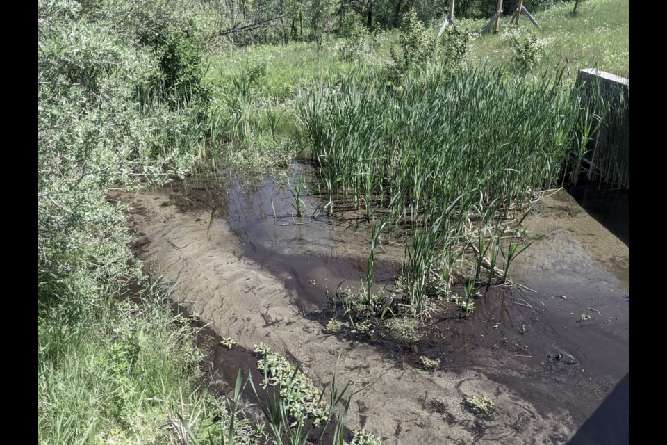
The land-use designation was originally changed in Barrie’s new OP, which awaits provincial approval, to natural heritage system as requested by the Nottawasaga Valley Conservation Authority (NVCA), which is the local conservation authority for this land.
OP feedback from the NVCA says this land is "recognized as wetland by the NVCA and, for planning purposes, is considered to be a part of the broader (Provincially Significant Wetland)."
The City of Barrie’s zoning bylaw also zones it environmental protection (EP).
EP zoning prohibits the land’s use for any buildings or structures — except for environmental management measures, environmental monitoring, environmental conservation, environmental interpretative facilities, lookout points, naturalized buffers, natural restoration, natural trails, bicycle trails, cross-country skiing, and picnic areas.
McCann’s agenda motion makes no mention of wetland boundaries or conservation authorities.
It says: "that the minister of municipal affairs and housing be requested to amend the land-use designation on the land known as the northeast corner of Ardagh Road and County Road 27 from natural heritage system to neighbourhood area, as identified in the attached drawings."
McCann said he could not recall the developer’s name.
MHBC Planning has a sign on the property, as does a city real-estate agent.
A natural heritage system can include significant wetlands, fish habitat, woodlands and valleys, endangered and threatened species, and areas of scientific interest, often linked together.
A neighbourhood area allows uses that include residential, long-term care homes, supportive housing, public services, commercial, retail and parkland.